


Could using autonomous systems and artificial intelligence (AI) help marine conservation?
Researchers and engineers from the University of Southampton are working together by using geospatial autonomous mapping tools and AI technology to survey and assess the health of seagrass beds in Studland Bay, Dorset.
Seagrass is a flowering plant which lives in seawater and forms meadows in the seabed. They are an important ecosystem offering habitat and nursing grounds to diverse species, and due to their capability to capture and store carbon, can help protect coastlines by stabilizing the seabed to reduce flooding.
The project, funded by the Southampton Geospatial initiative, involves deploying autonomous vessels capable of mapping the seagrass bed using cameras and acoustics.
The data will be collected and used to build a 3D digital map of the seabed and assess the health of the seagrass beds and extent of damage caused by boat anchors.
The state-of-the-art data is needed to inform nature-based solutions for coastal protection and habitat conservation in the Studland Bay Marine Conservation Zone.
Dr Hachem Kassem, Principal Investigator for the project, said: “It’s been great to work with different partners to come up with a much needed dataset that will really have an impact in terms of managing and conserving the seagrasses in the bay.”
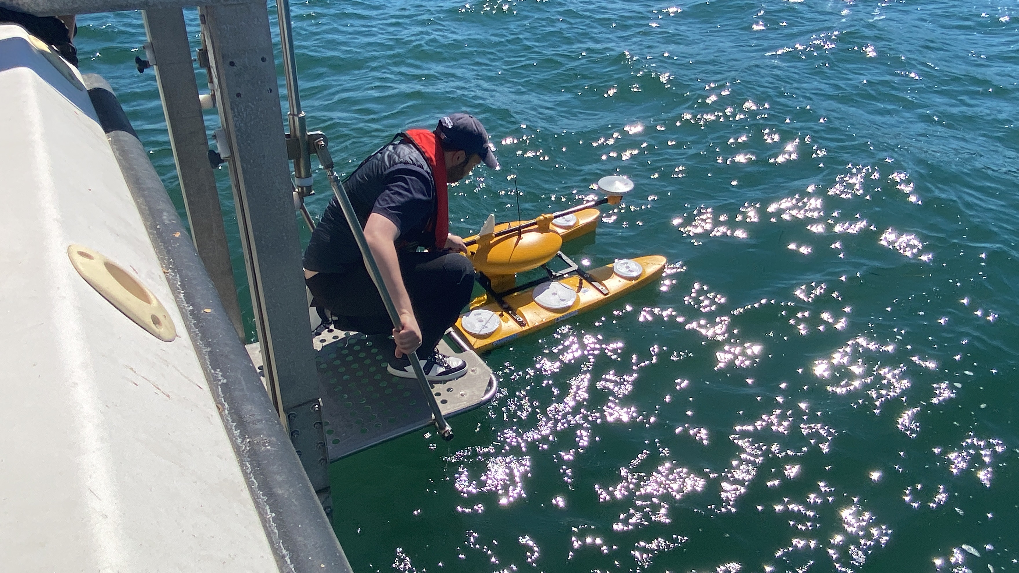 Dr Kassem deploying the picoCAT ASV in Studland Bay
Supporting the local community
The seagrass beds are within the Studland Bay Marine Conservation Zone. Working with organisations from the Studland Bay Marine Partnership, the team will share the data with the local community and assist efforts to protect this important habitat.
Hachem added: “Our work will support the local community and organisations that manage the area, to implement an appropriate conservation strategy to protect and promote the health of these seagrass meadows.
“This is vital as seagrasses help protect against coastal erosion and flooding, are incredibly efficient at capturing and storing carbon, as well as being a crucial habitat for a variety of species.”
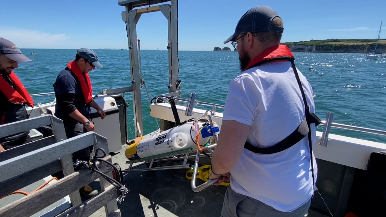 Professor Blair Thornton & Dr Miguel Massot Campos with the Smarty200
Technology sharing and collaboration
In partnership with Dorset County Council and the Dorset Coastal Forum, Hachem and the team have been conducting surveys of Studland Bay using two autonomous vessels.
PicoCAT is an uncrewed, autonomous surface vehicle (ASV) which carries acoustic sensors (multibeam echosounders) to map the seabed, examine the distribution of vegetation and the height of the seagrass canopy.
Smarty200 (Sparus) is an autonomous underwater vehicle (AUV) that carries cameras and optical sensors to survey the seabed and seagrass. The data collected (tens of thousands of images) will be analysed and interpreted by supervised AI to construct a 3D image of the seabed.
The team have also deployed pressure transducers to measure the tides and waves for the duration of the programme and completed repetitive scientific dives to the seabed. This is to assess the health of the seagrass ecosystem, understand how anchor scars have affected marine life and examine whether the installation of eco-moorings has prevented any further damage and/or promoted recovery of the seabed.
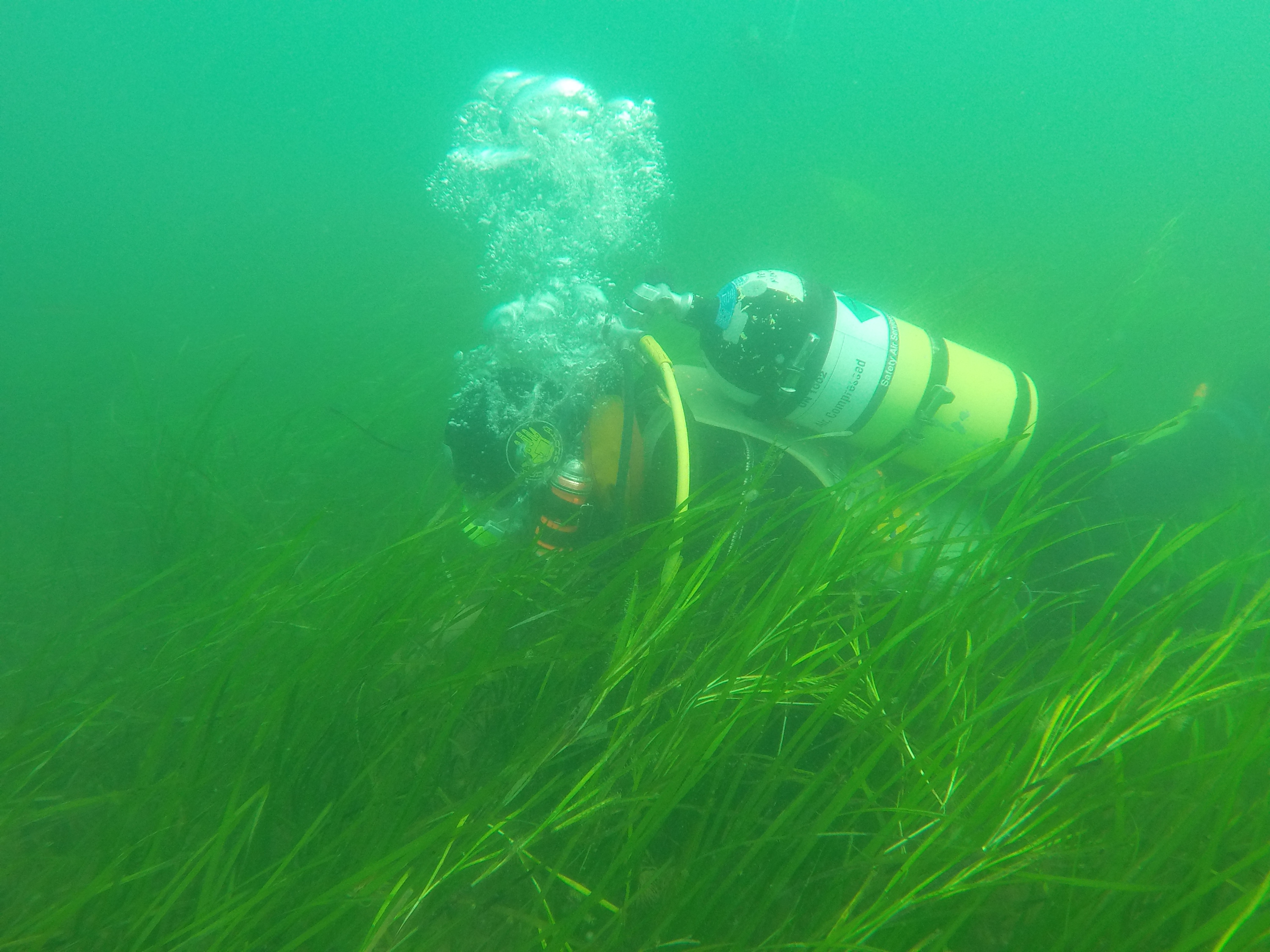
The team completed scientific dives on the seagrass bed
MSci Marine Biology and Oceanography student, Bronwyn Walker-Rouse, said: “It’s really important that we survey this because it’s a very popular boating area.
“There are so many different organisms like anemones, seahorses and fishes in the bay and you can really see why seagrass is an important habitat and why it’s such an important ecosystem to protect.”
The project involves academics and students from across the School of Ocean and Earth Science, Marine Autonomy in the IRIS Centre of Excellence, School of Engineering, and the Environmental Sensing at Southampton unit (ES@S) based in the School of Geography and Environmental Sciences.
Preliminary data will be shared in October and a paper will be presented at the Marine Autonomy and Technology Showcase (MATS) in November at the National Oceanography Centre.
* This article was originally published here
MSci Marine Biology and Oceanography student, Bronwyn Walker-Rouse, said: “It’s really important that we survey this because it’s a very popular boating area.
“There are so many different organisms like anemones, seahorses and fishes in the bay and you can really see why seagrass is an important habitat and why it’s such an important ecosystem to protect.”
The project involves academics and students from across the School of Ocean and Earth Science, Marine Autonomy in the IRIS Centre of Excellence, School of Engineering, and the Environmental Sensing at Southampton unit (ES@S) based in the School of Geography and Environmental Sciences.
Preliminary data will be shared in October and a paper will be presented at the Marine Autonomy and Technology Showcase (MATS) in November at the National Oceanography Centre.
Việc sử dụng các hệ thống tự trị và trí tuệ nhân tạo (AI) có thể giúp bảo tồn biển không?
Các nhà nghiên cứu và kỹ sư từ Đại học Southampton đang làm việc cùng nhau bằng cách sử dụng các công cụ lập bản đồ tự trị không gian địa lý và công nghệ AI để khảo sát và đánh giá sức khỏe của thảm cỏ biển ở Vịnh Studland, Dorset.
Cỏ biển là một loài thực vật có hoa sống trong nước biển và tạo thành những đồng cỏ dưới đáy biển. Chúng là một hệ sinh thái quan trọng cung cấp môi trường sống và nơi sinh sản cho các loài đa dạng, và do khả năng thu giữ và lưu trữ carbon, chúng có thể giúp bảo vệ bờ biển bằng cách ổn định đáy biển để giảm lũ lụt.
Dự án được tài trợ bởi sáng kiến Không gian địa lý Southampton, liên quan đến việc triển khai các tàu tự hành có khả năng lập bản đồ thảm cỏ biển bằng cách sử dụng máy ảnh và âm thanh.
Dữ liệu sẽ được thu thập và sử dụng để xây dựng bản đồ kỹ thuật số 3D của đáy biển và đánh giá sức khỏe của thảm cỏ biển và mức độ thiệt hại do neo thuyền gây ra.
Dữ liệu hiện đại là cần thiết để cung cấp thông tin về các giải pháp dựa trên tự nhiên để bảo vệ bờ biển và bảo tồn môi trường sống trong Khu bảo tồn biển Vịnh Studland.
Tiến sĩ Hachem Kassem, Điều tra viên chính của dự án, cho biết: “Thật tuyệt khi làm việc với các đối tác khác nhau để đưa ra một bộ dữ liệu rất cần thiết sẽ thực sự có tác động về mặt quản lý và bảo tồn cỏ biển trong vịnh.”
Các thảm cỏ biển nằm trong Khu Bảo tồn Biển Vịnh Studland. Làm việc với các tổ chức từ Hiệp hội Đối tác Hàng hải Vịnh Studland, nhóm sẽ chia sẻ dữ liệu với cộng đồng địa phương và hỗ trợ các nỗ lực bảo vệ môi trường sống quan trọng này.
Hachem nói thêm: “Công việc của chúng tôi sẽ hỗ trợ cộng đồng địa phương và các tổ chức quản lý khu vực, thực hiện chiến lược bảo tồn thích hợp để bảo vệ và thúc đẩy sức khỏe của những đồng cỏ biển này.
"Điều này rất quan trọng vì cỏ biển giúp bảo vệ chống lại xói mòn bờ biển và lũ lụt, có khả năng thu và lưu trữ carbon cực kỳ hiệu quả, cũng như là môi trường sống quan trọng của nhiều loài."
Hợp tác với Hội đồng Hạt Dorset và Diễn đàn Bờ biển Dorset, Hachem và nhóm đã tiến hành khảo sát Vịnh Studland bằng hai tàu tự hành.
Smarty200 (Sparus) là một phương tiện tự hành dưới nước (AUV) mang theo máy ảnh và cảm biến quang học để khảo sát đáy biển và cỏ biển. Dữ liệu thu thập được (hàng chục nghìn hình ảnh) sẽ được phân tích và diễn giải bởi AI được giám sát để xây dựng hình ảnh 3D của đáy biển.
Nhóm nghiên cứu cũng đã triển khai các đầu dò áp suất để đo thủy triều và sóng trong suốt thời gian của chương trình và hoàn thành các cuộc lặn khoa học lặp đi lặp lại xuống đáy biển. Điều này nhằm đánh giá sức khỏe của hệ sinh thái cỏ biển, hiểu được các vết sẹo neo đã ảnh hưởng đến sinh vật biển như thế nào và kiểm tra xem việc lắp đặt các dây neo sinh thái có ngăn chặn được thêm bất kỳ thiệt hại nào và / hoặc thúc đẩy sự phục hồi của đáy biển hay không.
Thợ lặn dưới nước trên thảm cỏ biển tại Studland
Nhóm nghiên cứu đã hoàn thành cuộc lặn khoa học trên thảm cỏ biển
Sinh viên Hải dương học và Sinh học biển của MSci, Bronwyn Walker-Rouse, cho biết: “Điều thực sự quan trọng là chúng tôi phải khảo sát điều này vì đây là khu vực chèo thuyền rất phổ biến.
“Có rất nhiều sinh vật khác nhau như hải quỳ, cá ngựa và cá trong vịnh và bạn thực sự có thể hiểu tại sao cỏ biển là một môi trường sống quan trọng và tại sao nó lại là một hệ sinh thái quan trọng cần bảo vệ.”
Dự án có sự tham gia của các học giả và sinh viên từ khắp Trường Khoa học Đại dương và Trái đất, Quyền tự chủ về Biển tại Trung tâm Xuất sắc IRIS, Trường Kỹ thuật và Cảm biến Môi trường tại đơn vị Southampton (ES @ S) có trụ sở tại Trường Địa lý và Khoa học Môi trường .
Dữ liệu sơ bộ sẽ được chia sẻ vào tháng 10 và một bài báo sẽ được trình bày tại Triển lãm Công nghệ và Tự trị Biển (MATS) vào tháng 11 tại Trung tâm Hải dương học Quốc gia.
* This article was originally published here

Post a Comment